23 Minutes to Survive: A Digital Race Against the Tsunami-Wave in the beach of Atacames, Ecuador
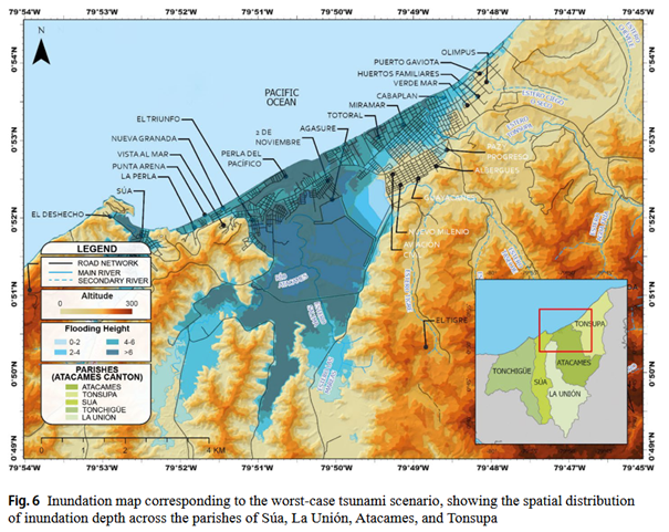
Contributed to by Geospatial Scientist Dr. Cesar Alvarez—as part of the Research Group for Climate Resilience of Human-Made Ecosystems—this study highlights how geospatial tools can effectively mitigate evacuation risks and protect highly vulnerable urban communities across South America. Integrating Physical and Social Dimensions to Strengthen Coastal Resilience Atacames, a major tourist destination on Ecuador’s northern coast, is located along the high-risk subduction zone between the Nazca Plate and South America. Despite its economic importance and vulnerability to near-field tsunamis, detailed risk assessments at the local level have been limited to date. This study argues that building coastal resilience requires a shift away from traditional, hazard-focused analyses toward a more holistic approach. By integrating centuries of historical records with high-resolution physical and social data, the researchers developed a framework that captures the complex, latent conditions of disaster risk in a rapidly urbanizing environment. Combining historical research spanning several centuries with hydrodynamic modeling The study focuses on the coastal communities of Atacames, Tonsupa, Súa, and Tonchigüe, which are particularly vulnerable to seismic disturbances. To account for the unpredictability of tsunami-triggering events, the researchers combined a historical catalog of nine significant events (1586–2019) with 18 synthetic seismic scenarios. These scenarios were processed using advanced hydrodynamic models, specifically COMCOT and MOST, to simulate wave propagation and coastal flooding patterns. A key component of the methodology was the integration of these physical parameters into a GIS-based vulnerability model with a spatial resolution of 10 m, which accounts for both the topography of the terrain and the complexity of the urban road network. Geomorphological drivers and socio-spatial risk hotspots The modeling results show that tsunami risk is not uniform but varies significantly along the coastal corridor. The synthetic worst-case scenario (Mw 8.8) yielded extreme run-up heights of 10.5 meters, with arrival times for the first wave ranging from just 23 to 34 minutes. Such an event would flood an area of approximately 29.9 km? and directly affect over 27,000 residents (66% of the population). The spatial analysis showed that while the underwater promontory of Atacames influences wave propagation, local geomorphological features such as river mouths and inland aquaculture ponds actually facilitate deeper inland penetration of the flood (see figure). These patterns formed the basis for identifying “risk hotspots,” where high hazard intensity intersects with structural social fragility. ? Multidimensional Vulnerability and the Role of Evacuation Capacity The study highlights a clear distinction between mere physical hazard and a population’s actual capacity to respond. Vulnerability is conceptualized as a multidimensional condition: Socioeconomic fragility is determined by poverty, vulnerable age groups (children and the elderly), and people with disabilities. In contrast, physical vulnerability is determined by functional territorial constraints, such as connectivity to the road network and dependence on potentially unstable bridge infrastructure. The study used a network analysis based on the “nearest facility” principle to identify optimal evacuation routes and found that 65% of the floodplain falls into high to very high risk categories due to these combined constraints. Furthermore, these findings were integrated into an interactive ArcGIS Online application, transforming complex scientific data into an operational tool for risk communication and community drills. Building Resilience Through Integrated Disaster Management The study concludes that assessing tsunami risk in near-shore environments requires a multidimensional approach that goes beyond biophysical exposure. The findings confirm that hydrodynamic data must be supplemented by local socioeconomic knowledge to reflect the actual challenges residents face in a crisis situation. Ultimately, strengthening resilience in Atacames, and similar regions along the Pacific subduction zone, requires policy measures that protect evacuation corridors, reinforce critical infrastructure such as earthquake-resistant bridges, and align urban growth with data-driven risk reduction strategies. This impactful research showcases the ongoing academic contributions of the Research Group for Climate Resilience of Human-Made Ecosystems at the University of Augsburg. As a research assistant within this specialized chair—which is an active part of the university's Institute of Geography, Faculty of Applied Computer Sciences, and Centre for Climate Resilience—Dr. Cesar Alvarez applies advanced geospatial tools to address overwhelming climate risks. The group's involvement underscores the University of Augsburg's commitment to developing practical, data-driven solutions that improve the living conditions and survival chances of the world's most vulnerable populations. Source: Parra, E., Geraldi, A., Melo, W., Alvarez, C. (2026): Integrated tsunami risk mapping and evacuation-route planning for Atacames, Ecuador: a multi-century catalogue, hydrodynamic modelling and GIS-based vulnerability approach. Natural Hazards 122, 456. https://doi.org/10.1007/s11069-026-08192-9 ?