Twenty years of climate and land use changes in Morocco
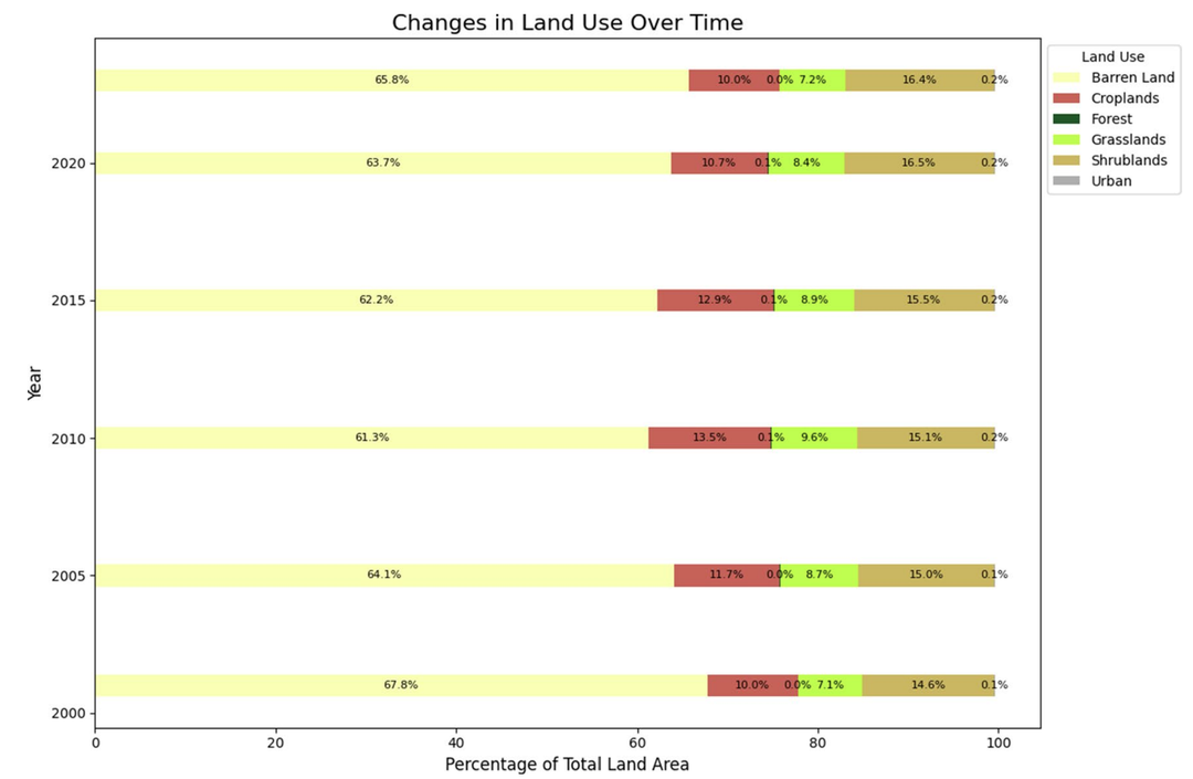
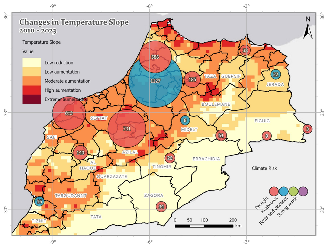
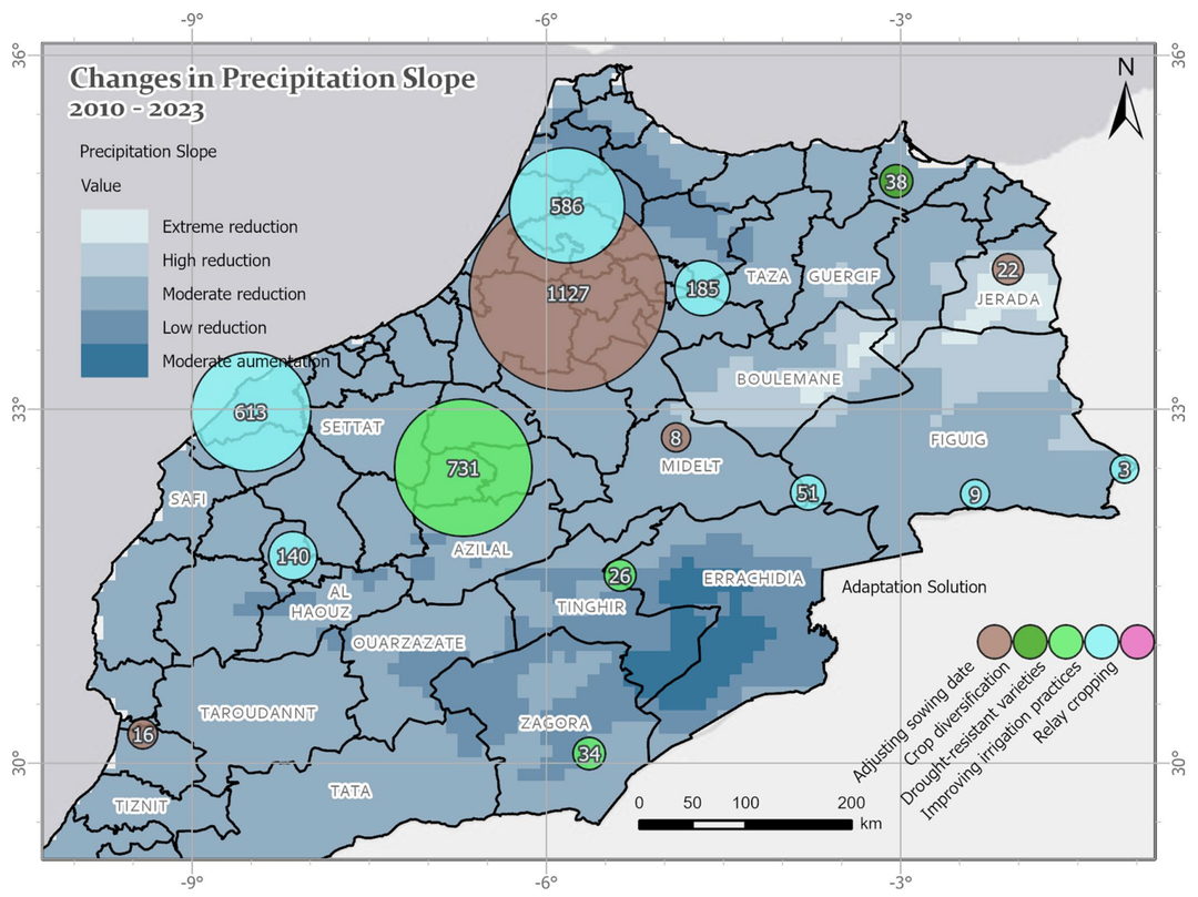
Long-term climate and land use changes in Morocco: spatial trends and farmers’ own perspectives In this research paper, the impacts of climate variability on cropland dynamics and land use changes in Morocco are examined over a two-decade period,2001–2023. The study integrates findings from innovative satellite-based Earth observation with the risk perceptions of over 3,000 farmers to obtain a comprehensive picture of agricultural vulnerability in one of North Africa's most climate-sensitive regions.?Such integrated approaches are of crucial importance as Morocco faces extreme water scarcity and a heavy dependence on rainfed agriculture. While the cropland area increased to 13.5% by 2010, it fell back to 10% by 2023 (see figure on the right) following persistent droughts, coinciding with a massive expansion of barren land. The analysis reveals that over 60% of agricultural zones show a decline in vegetation health (NDVI) and water availability (NDWI). ? Spatial Trends and Climatic Challenges The high relevance of this study stems from the discrepancy between large-scale climate models (or national reports) and the local reality of farmers. While national reports often lack spatially explicit, long-term assessments, this research bridges that gap by providing a detailed spatial analysis. Several critical trends were identified: Ultimately, these scientifically documented biophysical patterns closely match the experiences of farmers on the ground, who identify droughts and heatwaves as their primary climate risks. This indicates that there is no discrepancy in risk perception; instead, the scientific data validates the farmers' observations and provides the localized evidence previously missing from national reports. ? Innovative Data and Methods for Resilience Enhancement To efficiently process complex datasets and visualize long-term trends, the study utilized Google Earth Engine (GEE), a cloud-based platform for multi-decadal geospatial analysis. Key methodological innovations include: Despite these local efforts, the results emphasize an urgent need for coordinated, multi-level policy interventions. Individual adaptation remains fragmented and limited in scale, which is insufficient to counter the 70% decline in Morocco’s renewable water resources since the 1960s. The study highlights that long-term monitoring of climate and land use is vital to move beyond emergency responses toward structural transformations—such as dryland agroforestry and diversified cropping systems—to ensure long-term food security. The strong spatial and temporal alignment between scientific observations and the lived experiences of farmers is clearly demonstrated by the figures below, which visualize how environmental trends directly overlap with local perceptions and actions. ? Visualizing the Climate-Perception Alignment The left figure illustrates the relationship between rising temperature trends and the primary risks reported by farmers. The background map displays Land Surface Temperature (LST) slopes from 2010 to 2023, identifying areas of "extreme augmentation" where temperatures have risen by more than +0.0714 °C per year, representing a rise of approximately 0.71 °C per decade. By overlaying DBSCAN clusters, the figure reveals a precise geographic pattern: heatwaves are predominantly reported in the central region of Morocco, while droughts are the primary concern in the surrounding agricultural zones. This visual representation confirms that the scientific "hotspots" of warming correspond exactly to where farmers experience the most intense climatic pressure. The right figure focuses on the severe reduction in rainfall and the proactive responses of the farming community. The background highlights regions facing an "extreme reduction" in precipitation, with declines of up to 59.34 mm per year. This trend is particularly critical as total annual rainfall in Morocco's arid zones often ranges only between 50 and 200 mm, making such a reduction a threat to agricultural survival. Superimposed on this map, the DBSCAN clusters show that farmers are actively implementing adaptation strategies specifically in the areas of highest stress. These strategies include adopting drought-resistant crop varieties, improving irrigation practices, and adjusting sowing dates. Ultimately, these visuals underscore that the initial "discrepancy" mentioned in the study refers to a previous lack of localized data in national reports, rather than a conflict in perception. By bridging this gap, the findings highlight the urgent need for coordinated support to scale up these local efforts, given that Morocco has experienced a 70% decline in renewable water resources since the 1960s. Source: Alvarez, C. I., & Govind, A. (2025). Assessing climate and land use changes in Morocco (2001–2023): from a geospatial and farmers’ perspective. Theoretical and Applied Climatology, 156:420. https://doi.org/10.1007/s00704-025-05656-z. ?